
History of the Trail
The Chessie Nature Trail follows parts of the old canal towpath of the Maury River, known as “The North River” until it was renamed by the state legislature in 1945.
North River Canal
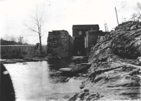 |
| Reid's Dam |
Before the canal and its towpath came, the river was run by whitewater craft called batteaux, narrow wooden cargo boats like large canoes about 40-45 feet long and 7 feet wide, pointed at both ends and steered by long oars. Replicas of these boats still run the Maury and other rivers in Virginia.
In 1851, the North River Navigation Co., later bought out by the James River and Kanawha (canal) Co., replaced the whitewater navigation with a flatwater canal system for large canal boats up to 90 feet long, towed by mules and horses from a towpath. The canal was a combination of ditch and slack water navigation. This company was responsible for extending canal construction along the North River up to the Lexington docks, which included the construction of Zimmerman’s, Ben Salem, South River, and Reid’s locks and dams – the remains of which can still be seen from the Chessie Trail. Boats – including packet boats carrying up to 60 people with room for social events, a kitchen/bar, sleeping space, and toilets – started using the canal system on Nov. 15, 1860. The remains of two canal boats have been found in the river, and more may still be present.
The North River canal was important for developing the economy of Rockbridge County, allowing passenger and cargo access to the larger markets of Lynchburg and Richmond. Jordan’s Point (now the trailhead of the Chessie Trail at the Lexington end) became a manufacturing and storefront center for commercial activity in the county, housing stables, warehouses, flour mills, a foundry and forge, and many stores.
The primary products shipped out along the North River included whiskey, iron, flour and wheat, leather, corn, and lime. During the Civil War, the North River canal became even more important for transporting supplies. So important, in fact, that U.S. troops under Maj. Gen. Hunter burned the Reid’s Dam lock gates and Jordan’s Point mill and warehouses in 1864.
Chesapeake and Ohio Railroad
As a result of problematic flooding and the increasing popularity of railroads, the James River and Kanawha Co. sold the property along the North River (now the site of the Chessie Trail) to the Richmond and Allegheny Railroad Co. (later the Chesapeake and Ohio Railroad Co., now the CSX Railroad). The railroad allowed for greater economic progress due to the high costs of canal maintenance and the improving capacity of rail transportation. Because the railroad purchased new land for its track instead of laying it along the entirety of the canal towpath, much of the property was left in a relatively natural state, which can still be enjoyed along the trail. The James River Line and Lexington branch of the railroad was completed in 1881; still-existing concrete markers along the trail with the notation “BF” and a number alerted railroad engineers to the distance in miles to Balcony Falls, an important stop near what is now Glasgow.
Although many wanted the Lexington station at Jordan’s Point, it ended up on McLaughlin Street near downtown Lexington (now the Omicron Delta Kappa headquarters). Jordan’s Point, however, continued to be important for the railroad system; since Lexington was the end of the line and space in town was tight, trains turned around just before reaching Jordan’s Point and backed into the city. This turn-around included a fairly steep grade behind VMI, which allowed a perfect location for cadets to grease the tracks and stop the train’s move into town – forcing the passengers to walk home from East Lexington. This mischief usually occurred when a W&L football team was returning from a game (causing them to miss the welcoming group of students waiting at the downtown train station) or when an opposing team was coming into town for a match with VMI (exhausting them with the hike uphill before the match).
The Chesapeake and Ohio Railroad Co. abandoned the railroad right of way in August 1969, when Hurricane Camille took out the wooden trestle across the Maury River parallel to Route 11. In 1978, the Nature Conservancy accepted the deed to the right of way from the railroad and held interim ownership until an appropriate permanent owner could be found. The VMI Foundation became that owner in May 1979. The deed was transferred in 2009 to Virginia Military Institute, which now maintains the trail for public use.
A Rail-Trail for All Ages
Today, the Chessie Nature Trail is enjoyed by thousands of residents, students, and visitors each year. Establishing and maintaining this recreational resource cannot be done single-handedly. Much of the initial work of converting the railbed to a trail was performed by the VMI Foundation with significant contributions of time and resources from local interest groups. Special acknowledgment goes to the Rockbridge Area Conservation Council (RACC) for ongoing advocacy of local trail systems, and Boy Scout Troop # 29, which installed the original set of mile markers along the trail.