
Trail Log
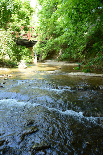 |
| Woods Creek at Jordan's Point |
Jordan’s Point Park and Route 11 Bridge: The Industrial Section
Jordan’s Point is the site of the confluence between Woods Creek and the Maury River. Just upstream of Jordan’s Point is an old millrace, c. 1810, built by John Jordan. In the mid-1800s, Jordan’s Point was home to a saw mill, foundry, forge, warehouses, and storefronts.
Once the North River canal was built, Jordan’s Point also served as the canal basin. Concrete pilings are still visible where the old railroad tracks crossed the river. The bridge washed out in Hurricane Camille. A pedestrian bridge was rebuilt as part of the Chessie Nature Trail was built on the pilings but was destroyed as well in a 1995 flood.
Route 11 Bridge to Mill Creek
This stretch of the trail is dominated by alien invasive plant species due to frequent human impact over time. Along this stretch is the first of the “BF” markers from the Lexington end of the trail. These concrete posts alerted the trains to the distance in miles to Balcony Falls, where the Lexington branch of the railroad met the Chesapeake & Ohio’s main line.
Rock outcrops to the sides of the trail are from Ordovician age Edinburg Formation – limestone formed in relatively deep water, folded during the Alleghanian Orogeny. Also on this stretch of the trail, but across Old Buena Vista Road, trail users can see Clifton – a house built in the early 19th century by Maj. John Alexander. Remains of the old railroad track can be seen in front of this house, marking the location where trains used to turn around and back into the city.
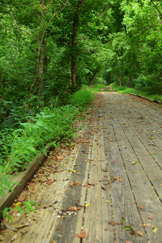 |
| Wooden Footbridge over Warm Run |
Mill Creek to Reid’s Dam
Note:
This portion of the trail is a wonderful wildflower walk in spring, but do not pick or dig up the flowers. In some cases, this can be a criminal offense.
Two wooden footbridges next to the Mill Creek entrance (towards the Jordan’s Point end of the trail) cross over Mill Creek; stone wall remains below the trail are left from the old mill race at that location. The Edinburg Formation continues along this stretch, on the left if facing downstream. Trail users can see the sediment layers, tilted due to mountain building and folding. The trail passes an old quarry site complete with drill holes – a clear sign of the blasting used by the railroad and canals for channel modification, canal towpath and rail bed construction, and local quarry of stones for both infrastructures.
Farther downstream, trail users can see the top of Reid’s Lock from a small observation area off the trail (a path to the area is typically cleared). Stonewall Jackson’s body was brought to Lexington for burial in 1863 via Reid’s Lock and Dam. After the canal era, the dam was used for hydroelectric power until the 1930s. Slightly farther downstream is a broad limestone outcrop right above the water – a perfect spot for resting or picnicking.
Reid’s Dam to South River
At the beginning of this stretch is a bamboo grove; although providing an exciting surprise, the plants are alien invasives and were likely planted early in the trail’s history. The trail passes over Warm Run just before passing under the I-81 bridge. The meadow near this bridge provides a robust habitat for wildlife and sits on top of one of the most important thrust faults in the Appalachians. This stretch holds a “BF 16” marker – again a reference to Balcony Falls.
Rocks between this marker and Zimmerman’s Lock are part of the Cambrian-age Conococheague Formation limestone, which has been thrust onto the Edinburg Formation.
This portion of the trail also passes through private pastureland; please exercise caution and respect while moving through gates. After passing through the first gate, a building foundation from the 1800s can be seen – probably the remains of a lock keeper’s house for the South River Lock. The remains of the South River Lock and Dam can also be seen in the river.
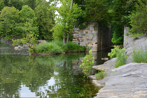 |
| Remnants of Reid's Lock and Dam |
South River to Ben Salem Lock
The original trestle bridge over South River was washed out during Hurricane Isabel in 2003. In 2021, with a grant from the Federal Highway Administration, the old bridge was removed and a new bridge put in its place allowing visitors to traverse the trail from beginning to end without any interruptions. The new bridge and a small parking lot were completed and opened in December 2021.
This section boasts some interesting geologic features, again featuring the Conococheague Formation – formed in an ancient, shallow sea. This limestone also yields a few small solution cavities and one large cave seen above the trail. A “BF 14” marker can be found on this stretch.
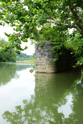 |
| Remnants of Zimmerman's Lock |
Ben Salem Lock to Zimmerman’s Lock
Again, this portion of the trail contains many interesting geologic folds and outcrops. A “BF 13” marker is located on the wide river floodplain, and just downstream of the marker is Zimmerman’s Lock and Dam. Although only a small portion of the dam remains, the lock is in quite good shape. Zimmerman’s Dam – like Reid’s Dam – was used for hydroelectric power for many years after the canal era ended.
In fact, it was the provider of electricity for Buena Vista in the late 1800s. A number of exposed caves appear in the rock wall towards this end of the trail. Because most caves are initially formed below the water table, these provide evidence of the Maury’s downward cutting through.